Some notes and reflections on where I do my research
Northwest Greenland
In Northwest Greenland, sea ice is diminishing and the sea is warming. Glaciers are undergoing significant melt at their fronts and on their surfaces, they are also retreating, and iceberg calving rates are on the increase. The inland ice is experiencing mass balance loss, more surface melt, and increased runoff. Marine biologists worry about overfishing in Baffin Bay and they are also concerned that polar bears, narwhals and other marine mammals have become vulnerable, endangered species in oceanic ecosystems under threat. The people who live in the region observe, and are affected by, these environmental shifts too, and over the last few years I have spoken with many of those I know there about how they feel their surroundings are being reconfigured, and even disfigured, by abrupt climate change and rapid melt.
Hunters and fishers in Northwest Greenland understand that when they set out to move and travel on sea, ice and land, they must do so with a careful awareness that the world around is capricious, fickle, and emergent, but the speed and extent of the changes they now experience around them challenges their anticipatory knowledge. Recent years have also seen more activities in the region that are related to extractive industry, including seismic surveys and the assessment of potential mining sites. This is often spurred on by a sense of increasing accessibility as the ice melts. In response, an environmentalist intervention seeks to designate large parts of the region as exceptional cryospheric spaces – last areas of ice – in need of protection as globally-vital ecosystems and wildlife habitat. The northern reaches of Greenland are represented as either empty frontier zones and wilderness areas (yet potentially rich in subsurface resources), or threatened, disappearing regions of ecological uniqueness.
The manner in which conservationists, environmentalists and scientists frame their approaches to protecting the last fragments of disappearing ice and Arctic species under threat is being unsettled and troubled, however, by Indigenous initiatives. Inuit calls for action in dealing with climate change, and for regulating shipping, commercial fishing and industry are expressed in the form of initiatives for co-management, community-based monitoring and Indigenous Protected Areas (IPAs) that recognise Indigenous knowledge.

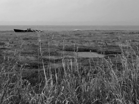
Dee Estuary
The Dee Estuary (Aber Dyfrdwy) forms the boundary between Flintshire in northeast Wales and the Wirral Peninsula in northwest England. It is a complex, dynamic estuarine ecosystem that is neither river nor sea. It is a threshold, a zone where the freshwater from the River Dee merges and mixes with saltwater and eventually flows into the Irish Sea at Liverpool Bay. It is a place where land appears to be immersed in water, yet comes into view and rises from it in the form of mud and clay foreshore, and sandbanks. The estuary also confuses one’s sense of coastline and water. It is watery and marshy, but landforms that emerge from it appear solid in places, inviting a walk out to the water’s muddy edges on firm sand.
The estuary can deceive, disorientate and consume. Sometimes, at low tide, it is difficult to see much water in the inner stretches, but a tidal surge can transform it suddenly and quickly into an overwhelmingly liquid space. The banks and shoreline are dotted with dangerous quicksand. These are not places to wander around in mist and fog. Areas of freshwater marsh and salt marsh stretch out from both the Welsh and English shores of the estuary and the water flowing from the Dee squeezes through shallow channels of sand and silt on its way to the sea. The sandbanks themselves are sometimes great expanses with names such as Dawpool Bank, Bagillt Bank, Salisbury Bank, Gayton Bank, Mostyn Bank, and West Hoyle Bank. Other names on maps of the Dee Estuary indicate channels and passages where boats and ships can navigate, such as Mostyn Deep, Welshman’s Gut, and Wild Road.

The Dee Estuary has been affected by sedimentation over centuries and has been modified by human intervention, most notably by the canalisation of a stretch of the River Dee flowing from Chester in 1737, which allowed land reclamation. In his Manual of Hydrology, published in 1872, Nathaniel Beardmore described the form of the Dee Estuary as an “injudicious mode of enclosure” which “unaccompanied by proper dredgings, has rendered useless what might have been a great improvement of its upper course; while the want of a proper application of capital lower down has permitted evils to gather strength. The sand-banks of the estuary are most enormous, and they stand very high and dry at low water; there is also the want of a great natural channel inside, to give direction and effect to the currents.” The national border between Wales and England runs along the Dee Estuary, yet its very nature and substance is uncertain and permeable. A fixed territorial boundary line has been imposed on something shifting and at times indeterminate.
Halkyn Mountain
Halkyn Mountain in northeast Wales is an upland common. It was shaped over several centuries by mining and quarrying. By the nineteenth century, it was one of Britain’s major lead mining areas. The extraction of lead ore and ancillary industries such as smelting continued to be major activities during the early part of the twentieth century. Fortunes were made by mine owners, syndicates and investors, although extraction had significant environmental, social and economic effects. The last lead mine closed in 1987, but the industry had been in decline since the 1950s and many mines were shut by the 1970s. Only a few people alive in the area today remember what Halkyn Mountain looked like during these final years of lead mining. Yet, when one walks on and around it, evidence of the industry’s past and its transformative reach is apparent everywhere. This extractive history is essential to understanding Halkyn Mountain’s contemporary character and the mining legacy is a key element in the construction of community identity and local heritage production.
The mountain is a multilayered place of surface, depth and volume and human and non-human entanglement. It has been made and transformed by earthly forces, weathering, geomorphological and human action; by subterranean water flow through Carboniferous limestone, and by digging, burrowing and extraction; by internal rupture, the tapping of fissures, tunnelling and the disruption of watercourses. It has also been shaped by the upheaval and movement of earth and rock; and by grazing, burning, clearing and churning up the surface. Like all landscapes, Halkyn Mountain is a place where things emerge, gather and interweave, but also rub up against one another – people, memories, stories, ruins, fragments of history, plants, birds, amphibians, limestone, minerals, underground water, industry, conservation interests, to name a few. It continues to be shaped and brought into being by landscape management and conservation strategies, by quarrying, by the life worlds of plants and animals, and by various perspectives on what constitutes a landscape and what infuses it with meaning.
